

(disclaimer: low automotive content) Sunday, November 4, 2007 dawned an exceptionally warm and sunny day. Usually by this time of year, cold, wet weather has set into the Oregon Cascades, with the first snow falls in the higher elevations. Seeing it as an unexpected last opportunity of the year to enjoy a day hike in Oregon’s vast wild woods, three Eugenians cracked open a popular trail guide and picked Olallie Mountain as their destination. They were University of Oregon Math Professor Daming Xu, my wife Stephanie, and I. Only two of us would ever return.
The thought could I have saved Daming Xu from his terrible death has haunted me often since that fateful day. So a couple of days ago we set out to retrace our steps, in part to see if I could find answer to that question, or at least some greater acceptance of how it turned out.
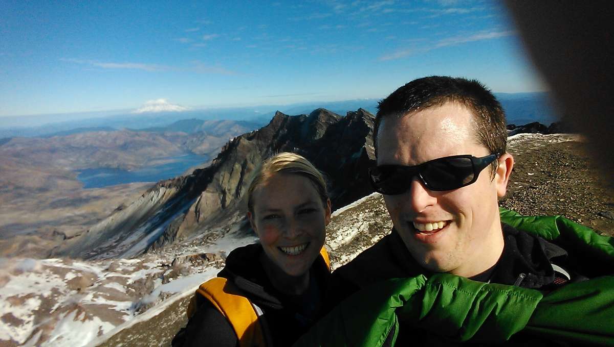
 image courtesy Wagner photo
It was a similarly sunny and warm as we again set out heading east on Hwy 126 along the scenic McKenzie River to take the same hike up Olallie Mt. to enjoy the sights and colors, and ponder the events of that day six years ago.

Like for so many other hikers in Oregon, William Sullivan’s excellent trail guides are our bibles. Over breakfast that morning in 2007– like almost every Sunday morning during the hiking season–I cracked open our well-worn copy of his 100 Hikes in the Central Oregon Cascades to pick one suitable for the day and conditions. We typically prefer hikes in the 8-12 mile range, but since the days were now short, and daylight savings time had just ended, I decided to find one on the short end of that range.

On page 154 I found one that would be just right, given that we were still lingering over a slow breakfast and the Sunday paper. Olallie Mt. was only 7.2 miles round trip, rated “Moderate” by Sullivan, but afforded excellent view of the Three Sisters, the dominant volcanoes in our region of the Cascades.

Olallie Mt. (B) lies in the Three Sisters Wilderness, in heart of the vast Willamette National Forest. It’s one of many smaller mountains of the Old Cascades, remnants of ancient volcanoes before a shift in the fault zones moved the active volcanoes, the tall and snow covered Young Cascade peaks that run in a line from California up into British Columbia, some distance further to the east.

After about 40 miles, we turned right on Aufderheide Road 19 and crossed the McKenzie, a splendid white-water river and famous for fly-fishing, rafting and kayaking. It was right at this turn-off that I had an unusual encounter with a Maserati 350o. Aufderheide Road 19 is one of the finest driving roads in the whole area, a winding ribbon of asphalt that follows the South Fork of the McKenzie and eventually connects Hwy 126 with Hwy 58 to the south.

But to reach our destination, we turned left after a few miles and drove over the dam at Cougar Reservoir, now well-drained in anticipation of the winter’s rains to come.

After a few more miles, we turned left on Forest Road 1993, one of countless gravel US Forest Service roads that snake throughout the National Forests, originally built to facilitate the logging on federal lands. Since the 1994 Northwest Forest Plan, logging on federal lands has been substantially curtailed, and these roads now are used more for recreational access. We had a 15 mile winding uphill drive to get the trail head, at Pat Saddle. As is all-too common, we did not seen another car since we left the highway.
These roads offer endless driving enjoyment, and that is a big part of our love of hiking: getting there (and back) is as much fun as the hike itself. Not surprisingly, I tend to drive more aggressively on the way in, and more relaxed on the way out. The “handling nanny’s” repeated beeping scolded me as my Xbox drifted on the gravel through the tighter corners. No, one doesn’t really want to slide off the road here, especially this time of year. It might be a long time, if ever, before someone happened to find one’s car at the bottom of the ravine or in the creek.

We parked at Pat Saddle, where two trails head off into the wilderness. We were the only car here. Although hiking is popular, there are so many trails that even on summer Sundays, it’s not unusual to find ourselves alone, although encounters with a few other hikers is common. But it was November already.

We headed up Olallie Trail, which connects with Olallie Mt. Trail two miles ahead. Beyond that, Olallie Trail heads east deep into the wilderness area, connecting to a number of other wilderness trails. With the right equipment and skills, one could hike or pack all the way to the Pacific Crest Trail that runs from Mexico to Canada, along the west slopes of the Sisters. The other trail head, French Pete Trail, heads to the right, around to the west and south side of Olallie Mt., along French Pete Creek.

I consulted Sullivan’s hand-drawn map once more, which reminded me that the key trail junction is two miles ahead. I was also interested in taking the additional .9 mile trail to Olallie Meadows on the way back, to check that out.

I have a pretty good sense of distance, and I started keeping an eye out for the junction shortly before we arrived. These junctions are not always well marked or obvious. The beargrass, which is actually a member of the lily family, is lush here, and the trail is almost obscured. Every second or third year, the beargrass sprouts a three-foot tall plume, covered with tiny lily-white star-shaped flowers.

Confirming the map, I found a little marker on a tree to the left, with an arrow pointing to Olallie Meadows and points beyond.

And on the right is a broken-off marker for Olallie Mt. We take it, for the last 1.5 steeper miles to the summit.

Near the summit, the trail breaks out of the woods, and the little vintage fire lookout building is now in sight. It’s one of only two of these structures still standing, part of a former network of lookouts. Its location up here is obvious, as the views are 360 degrees, and stellar.

The most impressive view is directly to the east, where the Three Sisters dominate the view. South Sister, the tallest, is to the right, and Middle Sister and North Sister huddle together to the left. From here to there is all virgin wilderness; a few trails, but no roads anywhere. Due to my camera’s lens, the mountains appear somewhat further away than they actually are.

South Sister is some 14 miles away as the raven or eagle flies. We looked at it closely, and I pointed out to Stephanie the route to the top that pretty much directly follows the ridge line on the right. It’s a pretty tough climb, 12 miles round trip, but that doesn’t really account for the very direct sections up the mountain itself after the hike to its base. The almost 5,000 foot elevation gain to the peak is punishing, as well as the loose scree on much of the steep sections.

I’d been up with son Ted (Ed) back in 1998, on a cold and windy September day right after the first storm of the season. North and Middle Sister are behind us , and other Cascade volcanoes beyond them.
But standing there now looking at South Sister, Stephanie decided that she was finally ready to tackle it, after resisting the idea for years. It was of course too late that year, but the following August in 2008, the two of us made it up, and reveled in the views from its top, encompassing much of Oregon, well into Washington, and the string of volcanoes that stretch in an almost perfect line north and south.

Now from Olallie Mt. we could also see most of them in the crisp fall air. To the north of the Sisters, the first little peak is Mt. Washington, then jagged Three Finger Jack, majestic snowy Mt. Jefferson, and in the distance on the far left, Mt. Hood, the tallest and most beautiful of Oregon’s volcanoes, near Portland.

Mt. Hood must be close to 100 miles away, but it’s perfectly clear to our eyes, if not the camera’s. Ted and his GF spends every Sunday zooming down its slopes during the long ski season (one can ski all summer on its highest runs). I try to join him a few times a year too.

Turning 180 degrees to the south is Diamond Peak, which Stephanie and our younger son climbed some years back. In the early days of West Coast mountaineering, the climbing clubs would coordinate an overnight hike to all of the Cascade Peaks from Rainier down to Mt. McLoughlin near the California border, and all build signal fires on their peaks in the dark to communicate to each. Now we instantly send our pictures standing on them, like this one Ted sent from the top of Mt. St. Helens just this past Friday.

To the west, the tree-covered Old Cascades give way to the foothills and then the Willamette Valley, whence we came from. The last ridge on the horizon is the Coast Range, and the Pacific lies beyond that. It should not come as a surprise that Lane County was (and still is) a primary source of timber and forest products generated on the West Coast, most of it the Douglas Fir used in wood construction. In this direction, these hills have all been logged at least once.

The lookout building is anchored by cables against the brutal winter winds. The roof is looking mighty bad.

It’s kept unlocked, to be used as a shelter for hikers wanting to spend the night up here. The stars must be amazing. In the center is the pedestal where the transit (or whatever the equipment used for determining the location of fires is called) once was mounted.

And in the corner is a stack of new cedar shingles. Looks like the hut is finally going to get a new roof before it deteriorates too far.

And on the other side, a temporary shoring wall has been erected. It’s good to know this Depression-era lookout will get some long-overdue repairs. But given the lateness of the season, that won’t be happening until next summer.

We savored the unseasonable warmth by taking off our shirts and charging our bodies’ solar cells for the long gray winter season ahead. And we enjoyed our al fresco lunch sitting on the rocks there.

But it was too rocky up on the summit for our customary postprandial nap. So we walked maybe 50 yards back down, and Stephanie waited on the trail while I scouted for a soft grassy spot some 10 yards off the trail. It was about 1:30 or so.

I heard, then saw someone coming up the trail; a middle-aged man, obviously Asian, wearing a white shirt and only carrying a light leather jacket, but no backpack. I guessed he was Chinese, for what it was worth. Stephanie greeted him cheerfully, and told him what a superb view was waiting for him at the top. He said very little, as if perhaps absorbed in his thoughts, and moved right on.
We spread out our tattered Space Blanket, and by the time we had taken our shoes off and stretched out, the hiker was already heading back down the trail. He couldn’t have spent more than a few minutes on the summit. In a hurry, on such a glorious day?
We enjoyed our nap in the bushes, and about a half hour later we reluctantly packed up and headed down. It was a bit after 2 PM, and the sun was already arcing into the west. I decided to not take the additional detour to Olallie Meadows on the way down, given the sun’s position. I’m sure we could have made it, but I’m conservative about some things.

As usual, Stephanie walked ahead. And when we got to the trail junction, she inadvertently took the wrong way, and headed towards Olallie Meadows and the wilderness beyond. For what it’s worth, it was literally the path of least resistance, and she never noticed the trail junction and the marker on the tree. I called her, and we headed down to the left, back to the trail head. Once again I reminded Stephanie that if I die early, she is not allowed to go hiking by herself. Ever.

When we reached the trail head parking lot, I was surprised to see a white Chevrolet Impala of semi-recent vintage parked there. Hmmm. We both thought that was a bit odd. The hiker we met would have long been back by now, unless of course he also decided to go to the Meadows on the way down. We agreed that the logical assumption was that it belonged to a hiker on the French Pete Trail.
But I thought to myself: in an Impala? Although I rather hate reverting to stereotypes and making assumptions, but as a car person, I couldn’t quite help it. I could just really much more see a Chinese person driving an Impala than the typical hiker or hunter hereabouts in the North West, where just about the only Chevy sedans are inevitably rentals. But this one was a bit too old for that. Trail heads are populated with Subarus, Honda CRVs, Toyota 4×4 Tacomas, and such. Maybe a vintage Corolla, or Honda Civic. Or a Prius, increasingly so. And of course a certain white Scion Xb with red wheels.

We put speculation aside, got the tea basket out of the car, and had our customary afternoon tea. Yorkshire Gold, with milk, of course. And home-made coffee cake, and apples. Tea time is sacrosanct, no matter where we are.
We lingered over our tea and drank in the surroundings for maybe a half hour, knowing this would be our last time up in the high country this year. I half-expected the hiker to show up anytime. That is, if the Impala was his car, and he had gone to the meadow before returning. As we packed up and left , the shadows were really getting long, and the temperature was dropping in the shade. No, it must be some backpackers or hunters that were on the other trail, the French Pete Trail, Impala notwithstanding. It was too nice and relaxing of an afternoon for other ideas or thought to intrude. As well as the only logical one…it’s not like this easy hike had any challenges. Maybe he was just taking his time; it wasn’t all that late yet.
We enjoyed the internal glow of a day hiking and the late rays of sunshine as we bopped down Forest Road 1993. On days like this, driving home is a meditative experience, like watching a video instead of actually driving the car. By now, my car well knows how to get us home by itself even if I am in the zone. No chatting or thoughts, except perhaps a mantra I used to say to my kids: It’s great to be alive in Oregon today….

Did the white Impala enter my thoughts anymore as we drove home into the sunset on Hwy 126? I can’t really say, because subsequent events have tainted the memories. As best as I remember, no. And by the next morning, Monday, there were more important things to think about.

On Wednesday morning, we sat down for breakfast table and Stephanie opened the newspaper. She called out: Paul: Look at this! There on the front of the Local section was a story about a lost University of Oregon professor by the name of Daming Xu, who had gone hiking in the Cougar Reservoir area on Sunday and never returned. Unbelievable!
The tv station had reported on it Tuesday night, but we don’t watch tv.
 rest of tv station’s report here
His family didn’t report him missing until Monday afternoon, and they didn’t know what hike he was planning to take, except that it was generally in the Cougar Dam area. Not until sometime Tuesday afternoon was his car spotted on Pat Saddle. So the first search effort only got underway late Tuesday, and they didn’t know which trail he had taken. My first thought: he’s dead already. Two nights in the woods with temperatures dropping down to around freezing, with no additional clothing since he had no backpack on. Hypothermia sets in quickly.
But how could he have gotten so lost? He must have taken the wrong trail at the junction like Stephanie did, and headed to Olallie Meadows and beyond. But surely he noticed how different that trail looked, and the fact that there was no meadow on the way up. It was only a mile to the meadows, and there was plenty of time to turn around.
I immediately called the Sheriff’s Department, and told them of our seeing Dr. Xu on Olallie Mountain, and of my certainty that he had headed into the wilderness on the wrong trail. They sent a deputy over to get a statement from us.

A proper intensive search didn’t get underway until Wednesday, now focused on the trails the he had to have taken. Of course, the Olallie Meadows Trail has a number of trail junctions further in the wilderness. Searchers found what they believed to be his tracks near Bear Flat, but they then ended, or they lost the tracks. A helicopter with infra-red capability joined the efforts. Thursday’s newspaper report here.
Xu’s cell phone, heavier jacket, and water were still in the Impala. But family and rescuers were still still sounding optimistic: Lane County Sheriff’s Lt. Jeff Smith was “also was optimistic Wednesday. The search area offers plenty of shelter and water, and the weather hadn’t been extreme, he said. (high) Temperatures on Wednesday reached about 50 degrees. “If a person has any kind of wilderness survival skills, they could make it,” he said. I didn’t feel nearly that optimistic.
On Thursday, the weather deteriorated, and cold rain and snow moved into the area. Now I knew without any doubt that Daming Xu was dead. No one can survive more than a couple of days without warm clothes. And even then, it quickly becomes difficult.
By Monday, Nov. 12th, the official search was called off, due to bad weather and the reality that Xu would never have survived that long. Friends and volunteers continued to search, and on Nov. 15th, found the only clue to his whereabouts: one half of Sullivan’s trail book, through page 157, which included the Olallie Mt. hike on page 154. The other half had been found in his car. So he had the trail map with him, which only compounded the mystery of how and why he got so lost.

The trail book was found in a very rugged area of the French Pete Creek drainage, on the south side of the mountain. He must have followed the trail to Bear Flat, then headed down French Pete Creek, where there is no trail, and the going is extremely difficult due to endless fallen trees, rocks and steep terrain. For what it’s worth, if he had made it further, he would have eventually hit French Pete Creek Trail, which would have either taken him back to Pat Saddle or down to Aufderheide Road 19. How long he manged to survive, and how long it took him to get where they found the book is speculation. I strongly suspect he died on the second night out, from hypothermia, if not already the first.
One year later, a group of 45 volunteer searchers spent 400 hours looking for remains of Xu’s body, but nothing was found. That’s not uncommon, after so much time. No less than 240 persons officially remain missing in Oregon’s wild areas since 1997.

In the summer of 2012, another one joined the ranks. Jake Dutton (above), 32, headed off purposely into the wilderness towards the Three Sisters from almost the same place where Dr. Xu started his hike. Dutton was an experienced backpacker, carrying gear and supplies, and it was summer. But he never returned, and his body was never found.
Leaving an established trail even for a very short distance can be dangerous, as it’s so easy to become disoriented among the tall trees. There are often no landmarks to orient oneself with. On one of my first hikes in Oregon’s woods, I once bushwhacked a couple hundred yards with my younger son to a remote lake described by Sullivan in his book, and had difficulty finding my way back to the trail. It scared me a bit, and ever since, I’m very reluctant to leave a trail unless I have landmarks in sight, since I didn’t carry a GPS or such. And since the event on Olallie Mt., I usually make it a point to let my younger son know exactly what hike we’re taking, even if there’s two of us. Certainly so if I were to go alone.
In the days after Dr. Xu’s disappearance, I couldn’t stop thinking how I might have called the Sheriff’s Dept. Sunday night to tell them that there was a car still parked up there, and saved him. But realistically, it just didn’t call out for that, and I doubt anyone would have, unless they had good reason to think someone was truly in trouble. It was a warm day, an easy day hike, and someone just wandering off into the wilderness without realizing it seemed utterly implausible. One just assumes that another hiker knows what they’re doing.
And even if I had called, it’s hard to say whether they would have found him in time. There were many trails he could have taken, and its possible that he expired on that first cold night without a proper jacket.
The other day when we re-enacted and photographed this hike, we were again the only ones parked at Pat Saddle. But when we came back down, there was a Subaru Forester (not pictured) parked there also. And while we were again having tea, pondering whose car it was, a hunter dressed in camo walked in from the French Pete Trail, got in the Forester, and drove off. That mostly validated the conclusion we arrived at in 2007: that the Impala belonged to someone on that trail. Although it is a wee bit harder imagining a hunter getting into a 2003 Impala. But hardly impossible.
Nevertheless, I was glad not to have to even consider whether I should take down the Forester’s license plate and call the Sheriff. If everyone did that for every car still sitting at a trail head at the end of a sunny day in Oregon’s vast woods, it would be ridiculous. Ultimately, it’s the responsibility of those heading out into the wilderness to make sure they understand the risks, and to prepare and act accordingly. It is called the wilderness, after all.


That was awful, though of course I couldn’t stop reading.
Paul, you may want to clarify that the professor was on his own solo journey, and wasn’t hiking with you and Stephanie from the beginning. I suspect I’m not the only one who read this part and thought that was the case:
“They were University of Oregon Math Professor Daming Xu, my wife Stephanie, and I. Only two of us would ever return.”
I thought that initially as well, but given the arc of the story (and the tragedy) I think it reflects very accurately on the situation. They were forever joined, albeit briefly and by no choice of their own.
Fair enough, Mike. Still found the whole story unnerving. Nothing compared to living through it, I’m sure.
I didn’t think the verbiage was confusing at all. The couple was already upon the summit when the professor showed up.
All in all, this was a fine essay.
But, my thoughts to the author: you SHOULD carry a compass AND map AND gps with now. You probably do now but you indicated that you never used to.
I’m personally spooked about getting lost in the woods. There was a missing hiker recently found on the AT…. or I should say her remains were found…. as she had been missing for two years. She went off the AT trail only about 3,000 feet where she hunkered down in her tent. She died there… in a zipped up tent… inside her sleeping bag… of exposure and starvation. Dying a slow death in the woods is one of the creepiest ways to go. If you go from starvation. There’s always the chance that before you die, a mountain lion or bear might choose to begin munching on your body… while you still are aware.
I still don’t carry a compass or GPS. But then I stick to the trails, and I recognize when I’m not coming back on the same trail I went up with.
In some of these 240 cases you have to think the person did not want to be found. I sure am not saying that is the case here but I will say that you have no call to punish yourself over this.
Every now and then a low car content article is called for. Yours are always interesting.
Yes, some of those missing may have taken their own lives, and foul play is presumed in some others.
This doesn’t make the passing of the professor any less sad, but I’d like to consider the possibility that he was struck by a painless and fatal medical condition while doing something both beautiful and enjoyable.
Over the past 20 years I’ve seen a few colleagues die in a similar manner. While I can’t speak for everyone, I’d rather go out that way, or peacefully in my sleep.
A terrible tragedy. I found it interesting that he was not more interested in a brief conversation when you met, but then I am not schooled in “hiker etiquette” and perhaps he was just looking for solitude.
This strikes me as another of those situations that we in modern civilization get sort of cavalier about – there is still danger out there in remote wilderness areas. Nature can be a harsh judge of human error.
That struck Stephanie, rather strongly. The typical scenario is for a bit of interchange, for sure. Perhaps he was working on a mathematical problem? Or maybe a cultural thing?
I think he was thinking. Mathematicians are like that. (Extended comment below.)
Interesting story, can we go hiking if I can ever get out there?
I once had a similar issue on a day hike with my Brother.
We were on our way back from climbing Silver Peak in Killarney, and we came to a nice little waterfall. My brother started taking pictures of the nice waterfall, and I asked myself “so if this waterfall is so nice how come we didn’t take any pictures of it on the way up?”
Turns out we’d taken the wrong fork in the path, and although we weren’t headed into vast wilderness like unfortunate Mr. Xu it would have been two days before we emerged at the other trail head.
I was able to figure it out because I had a good map, a compass and some spatial awareness. Even for a day hike these things are required because in the wilderness little mistakes can make big problems.
Sure!
Sorry. “Mathematicians are like that” is an absurd thing to say.
The man who initially taught me the hobby of hiking was a retired math teacher. You’ve never met a more jovial, talkative man.
My guess is that his personality was simply one where he was not interested in human interaction that much. I’ve met hikers on the trail who will stop and talk. I’ve met some who are sullen and silent.
The chance that he had a stroke or cardiac arrest was a strong potential. Particularly if he knew he was lost and began to panic… with rising blood pressure and stress.
Life has it’s occasional what ifs, something doesn’t smell right, I think that somebody may be at risk, etc. But, at the time you left the parking lot, it was just as probable that that Mr. Xu was right behind you. As you pointed out, you can’t always report the last car in the parking lot as a problem just because it is the last car and it’s just a bit late. Even with a report, it seems likely Mr. Xu would have expired before the authorities even took action, let alone what they could have realistically done at that late point just before dark.
Interesting story of caution, common sense, and a peek into your beautiful back country and the recreational opportunities it affords – and the respect you have to give that opportunity.
Paul, I am sure it was somewhat cathartic to revisit the scene and hike and write it up. It was a good read. You shouldn’t flog yourself for having missed the first news reports and questioning yourself if you could have made a difference at that time.
You vigilance and awareness of your surroundings serves you particularly well. Trying to relate your thoughts and concerns (could that be that guy’s Impala and why would he not be back yet?) based on your personal “radar” is so difficult. That is like many of us trying to guess the intensions of an unfamiliar person wandering through or parked in our suburban neighborhoods and trying to guess if they may be up to no good. For a moment one might consider…should I call the police? Then life moves on to other things when there seems to be no imminent danger. Such fleeting thoughts can haunt when something is later found to have gone awry.
Again, good story with plenty of lessons we can relate to.
“We lingered over our tea and drank in the surroundings for maybe a half hour, knowing this would be our last time up in the high country this year.”
On the positive side, each September I find myself on a lake in the bow of my runabout, or perhaps sitting on the swim platform with my feet in the water, meditating on the likelihood that I’m on the last trip out for the season. I try to soak up some extra sun for the coming winter. The sun starts to dip, and I long for just a few more minutes. My kids start to think I’m a bit crazy.
I have hiked extensively in the United States and Canada and have often wondered why park rangers are often so stingy about marking trail junctions. Many times I have taken a wrong trail, or missed a turn that could have been easily marked. It may be obvious to them on a horse but not necessarily to a backpacker.
I agree….why are these trail markers allowed to deteriorate so badly? Surely having fairly new readable trail head markers won’t take anything away from the wilderness experience.
Government loves to chant about “trails and parks” because after all we should all worship “the environment.”
But when it comes down to it, the government loves to pretend its doing us all a favor by collecting taxes, creating the parks (often nothing more than homeless camps in the making) and then ignoring maintenance.
The taxes continue to be taken from the public but the trail markers are, despite the least costly and least effort to maintain, the markers are just forgotten.
I called once about a trail marker that was buried in brush and small trees which had clearly been ignored. The girl on the phone in the ranger station just laughed to her co-worker as I was suggesting they fix the problem. It was never fixed. That was on a trail known as the “Bay Area Ridge Trail” in the San Francisco Bay Area, CA.
By the way, that trail has its own park bureaucracy to “maintain it and safeguard it” despite the trail being superimposed upon other trails all over the Bay Area which have their own park bureaucracy to “maintain and safeguard.” You can’t have too many park “rangers” running around. They are REALLY needed.
I would like to communicate with you about genealogy relating to the Dael family. I’m not sure if you will get a notification but please contact me at petedale59@hotmail.com
Having seen these mountains from the east side, this is a vivid reminder of what Mother Nature can deal to a person.
There is likely nothing that could have changed the outcome of this situation; even if you had reported the Impala sitting there toward the end of the day, was that indicative of anything? Not really. I am quite surprised at the number of people who have gone missing.
Most of us at some time or other are dealt a situation where we question our level of involvement and whether it could have changed the outcome. In 2006, I had an employee in which I had a gut feeling that something was amiss at home. Gaining another job that required a relocation, I started the new position elsewhere on a Monday; she was murdered the following Saturday due to domestic violence. I identify with this article as I still ask myself the same questions.
This was a fascinating piece, and it recalled for us the incident when the Silicon Valley guy and his family had gotten themselves quite lost trying to get from Merlin, Oregon over the coast range to Gold Beach. We had driven that road just a year or two before, and I like to think that most people, like me, would have found it easy to stay on the right road, ignore all the logging roads headed off seemingly every which way, and arrive at the destination more or less on schedule. But although we made the trip in summer rather than in autumn as those folks did, thinking about their journey’s untimely end still gives me an eerie feeling.
There was another time when we explored up the High Deck Road, which goes up into the hills from the Short Covered Bridge and Cascadia Park on the north side of the Santiam River. After only four or five miles we got to a place where roads went off in three different directions and it was impossible to tell which was the main road. Time to turn around and head back. Maybe on a day when we have more time we’ll look again.
I certainly enjoyed the account of your hike, and the accompanying video.
In this week’s Radiolab episode (link) the writer David Leavitt says this about genius mathematician and war hero Alan Turing, “He looks like he, like a lot of mathematicians, lives simultaneously in two different worlds: the world that the rest of us live in and … a kind of extraordinary world of abstraction.” Turing also died tragically and far too early.
I think Dr. Xu was literally lost in thought. I wonder if he solved his problem before the end.
That’s what we both thought right away when we heard he was a mathematician. There’s also the compounding fact that he took up hiking late in life, just a few years before his last one. Being out in nature was not something that he grew up with, and he undoubtedly never really considered the risks and the need to stay focused.
My father was a lot like that, always lost in his thoughts. But he was an avid hiker and climber since his youth, so he cultivated an excellent sense of his surroundings and self-preservation, despite that tendency.
Turing died in suicide.
As for dying “early,” people die from before birth to during birth to every decade of life. That phrase “died too early” really doesn’t make sense.
I think a more apt way of describing the situation would be to say it was sad that he lost his life by being lost. If he was lost and didn’t intentionally do something to end his life.
To discover you don’t know which way to walk would be horrifying. I read an account of a woman who was lost in a side canyon of the Grand Canyon for about 4 weeks and was nearly dead from starvation when the Indians of the nearby reservation found her. She had found a small spring so she had water but no food. She said later she had no light at all and the first night was so black that she cried all night. Alone. In the dark. Lost. No food. She couldn’t escape as the spring was her only source of water. She sat there. Nobody knew where she was.
A great story and look into the Oregon Cascades. If you were out this past weekend, you lucked out. Washington Cascades had snow and winds, with the snow level down to as low as 3000Ft.
My 3 sisters and I almost went to the mountain (Mt Rainier National Park), via the Longmire entrance Saturday, but my middle sister was sick, so we went yesterday, and while no wind or anything like that, it WAS snowy to some extent, a dusting at Longmire (it was at 2700Ft), but a bit more than that higher up. We could not get to Cougar Rock as just before a bridge, signs said, traction devices beyond this point. We had none and was in a Honda Oddy, a later one at that. Cougar Rock campground and picnic area is just beyond that bridge. It was where we liked to go to have our picnic at the mountain.
The reason was we were celebrating our late parents as it was one of their favorite places in the area, the other was our good friend’s beach cabin out on the Washington coast. We’d lost our our father 15 years ago on Oct 25, and Mom on Oct 27th of last year.
Today, it was 49F in Seattle, it’s currently 47, though it feels more like 46, and the low overnight will be 45, with showers late.
We did that re-enactment hike a week or so ago, when the weather was still great. But sure enough, that ended right on cue, a sit always does this time of year right around Halloween. It’s maybe a couple of degrees warmer here, but socked in.
We did go up in the woods for more mushroom hunting on Sunday, but not that far or high. And we dressed for the occasion.
Ah ok…
I was thinking, hey waitaminnite… They had gorgeous weather, and we didn’t! Obviously that wasn’t the case.
Yeah, right around the first of Nov, the weather gets winter like in a hurry.
Poignant article Paul, thank you for posting it.
Beargrass – I have never seen it as dense as what is shown in your pics. Do you have a copy of “the field guide to Rocky Mountain windflowers” ? One of the Peterson series, written by the Craighead brothers. I think I am right in remembering the entry on beargrass warning about how slippery it is to walk on, on a slope. Something along the lines of ” having your feet yanked out from under you”
Alistair
No. But it sure is slick and tough.
Very thought provoking Paul, and to be honest, it creeped me out a bit… I often geocache in out-of-the-way areas, and being single I’m usually alone and often bush-bashing to find the cache (you’ll have to look up geocaching to know what I mean, it’d take ages to explain). I always have my GPS and phone with me, but they’re not always great under bush cover. Think I’ll pay more attention to letting folks know where I’m going now…
Sad story, Paul. It’s perfectly understandable why you or anyone else would be haunted by such a chance encounter. But that is exactly what it was…A chance encounter.
Consider how many people you potentially (probably) cross paths with in the course of your average day that later on meet with some ill-fortune. The situation you were involved in is more notable because you were in the mountains and didn’t have all the background clutter of daily human civilization to contend with. The point I guess that I’m trying to drive at is that people are on their own pre- or self-destined paths and to a large degree are responsible for their own actions and the consequences of those actions. It doesn’t make the situation any less tragic though.
I grew up in the heart of the Appalachian mountains (a true hillbilly!) and while the Appalachians aren’t quite so vast as the mountains you live near, they are still a fairly dangerous place for those who go exploring them ill-prepared.
Hiking in the wilderness is wonderful, but like almost everything else in life, it’s not something to be undertaken thoughtlessly. It’s the hiker’s life on the line, each and every time.
Don’t let it nag at you and take it for what it is..A valuable reminder and lesson.
What an incredible read. I feel sad for Dr. Xu’s family and feel bad that you & your wife experienced this. Thanks for sharing it with us. The lack of closure is what would bother me more than anything.
When I initially heard about this story I was shocked since I occasionally saw Mr Xu at the local YMCA.
While there I attempted to make conversation with him twice and he was nice but of very little words. I understood that to some extent being of similar background ethnically. Your story only bolsters that perspective as your talk on the trail had similar ending.
Having thought about him over the years and what might have happened I appreciate your story and effort to recant the details.
It touched me on several levels having almost died of exposure myself. As you know, a little scare leaves you much more aware.
We just did this hike on Friday — 11/4/2016 — and I remembered the missing professor but thought he was at the Lowder Mt trailhead, not Olallie. But it was nagging me so we looked it up and found your story about it. Coincidental that we went on the same day — only 9 years later. We also did this trail many years ago, maybe 15(?), and saw a bear and her cub on the trail right by mosquito creek. In all my years of hiking, the Olallie trail is the only one that I’ve ever seen a bear on. We have seen bears in that area but were always in the car on the road.
I’m curious to know where the halved Sullivan book was found. You said it was found in the French Pete drainage area — but how far off the trail? There is a loop trail that goes around Olallie and hooks up with the French Pete trail — and that loop trail crosses French Pete on the southwest side of the mountain. Do you have any more info about the location?
If Professor Xu was planning to do the loop trail then that would explain his short visit at the summit. The back of the loop from the summit of Olallie is 12.1 miles according to the Three Sisters Wilderness map I have. Sullivan’s map doesn’t show it but alludes to it with the Bear Flat trail showing 9.8 miles to Pat Saddle. If the book was found further down the creek away from the trail, then maybe he ran into a bear and had to go off the trail. That’s one scenario I’m entertaining after running into a bear there myself.
Very curious —
There’s no doubt in my mind that Prof. Xu did not intend to make that long loop hike for two reasons: it was not on the only map he had, and it was way too late in the day already, given how short the days were by Nov 4, the first day of non-daylight savings time. It would have been suicidal to even undertake it that time of day.
That would have been a very ambitious hike anytime, and Dr. Xu was known to take fairly modest hikes at most. No doubt he took the wrong trail at the junction on the way back, and eventually got lost and confused.
Black bears are completely undangerous, and will always run away from humans. We’ve stumbled into them in the general area on trails, and they always run off when they hear/smell humans. It’s very different than with grizzleys.
The book was found quite a long ways from the nearest trail, in a very rugged drainage of French Pete Creek. But if could have continued down it another day, he might have made it. But it wa sprobably his third day out already, and the weather was getting colder.
Response to Paul:
Paul, I hate to be the bear-er of bad new (pardon the pun), but all wild animals are dangerous. Its just a matter of how much damage they can do to a human if the animal attacks for any reason.
A young man was mauled to death by a black bear back east about a year ago after that rogue bear followed him when his group disbanded and fled during its approach. His camera had several photos of the bear approaching him as he was separated from his friends. Similarly, another rogue black bear attacked a man on the Canadian side of the border as he was, unfortunately, cornered in an outhouse doing business. And there was a 3rd example but I can’t think of which state it was in. It had attacked several people over a several days so rangers didn’t know if it was one bear or several. In all these examples, the bear was not a grizz but instead a common black bear.
And, just try going near a sow black bear with cubs around to see just how “undangerous” black bears can be. They’re fully and famously dangerous when cubs are present.
That said, the story of the Professor is an interesting one. Even if a wild animal didn’t cause his death, you can bet that they consumed his remains. A skier went out of bounds on Mammoth Mountain, California several years ago and all that was found the following spring were his ski boots (containing his feet).
I’m not certain of the investigation details, but there are also the suicides that take place in the wild. But a missing person case usually incorporates those questions to try and eliminate that as a reason for the missing status.
Well Folks, Lets not forget about the forest people,Sasquatch,Ive been around them in the cascades for 50 years. Im pretty sure thats where alot of these people are going.Ive ran into many bad attitude bigfoot and the good ones protected me,most are nice, best advice,stay outa their home, unless you know them. I know them! Be safe! Think like the forest people and bring Love! Dont disrespect them, speak up! You are in their home!