(disclaimer: non-automotive personal content ahead) I’ve been spending quite a bit of time at our Port Orford property since we bought it in September. Some of you have suggested updates, so here’s a bit of one that might give you a sense of what we’ve been doing there how we spend our time (working and playing) and where the project is going.
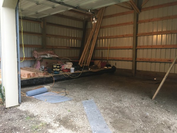
We came back after ten days last Wednesday, and this is the last picture from that trip: I’m savoring the new floor in the pole barn, the first, biggest and one of the hardest jobs in its conversion into a cabin. So far, that is.
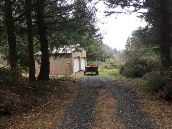
From Coast Guard Hill Road, our place is heavily wooded and the pole barn garage is barely visible. It was even less so before we did massive amounts of thinning and pruning.
Here’s the driveway, and where I’ve been parking the van, as the lower area got a bit soggy during the wettest December in some time.
The van is a superb home away from home, and I appreciate it more than ever. It’s surprisingly comfortable for weeks on end, and everything has worked flawlessly; there’s not one thing I’ve had to fix or wish I had done differently in the conversion.
Having power has been a boon, and an unexpected one, as I literally stumbled into it hidden in the dense undergrowth. More on that later. But that means I can run a portable space heater and run the water heater, fridge and other appliances without the batteries. Good thing, as the solar panel is useless in the woods.
Backing down the slightly curving driveway with the utility trailer, especially when arriving in the dark of night, has been a bit of a challenge. Let’s just say I had to revive some dormant skills. During the rainy period in early December, the un-graveled driveway got slippery, and I just barely made it out with the van, minus the trailer. A next door neighbor has a little 4WD Kubota tractor, and he pulled it out for me.
The very next day I made three trips with the trailer to Bandon, 26 miles north, the nearest place to buy gravel. Getting used to not having so many resources close at hand is one of the realities of living in such a small town, although curiously enough, there are two hardware stores that stock the more common sizes of lumber and such.
Here’s how my day starts there every morning: with a walk up to the former Coast Guard station at the top of the main head, which is now a museum and a state park. It’s one-third of a mile up the road from our place to the station.
One of the old legendary self-righting, self-bailing 36′ rescue boats is on display. It was powered by a Detroit Diesel engine.
Here’s a bit of info on these boats and the brave men who went out in the worst storms (click all images for max. size).
Their motto was: “You have to go out, but you don’t have to come back”.
The boathouse was way down in a sheltered cove three hundred feet below the station.
Some 530 concrete steps lead down there. That must have been fun to run down on a pitch black stormy night. The piers of the ramp are still visible in the water, and that concrete sea wall was built to protect it.
The trail and steps down there are technically closed, but I went down one morning this past week. This is from about three-quarters of the way down.
This is as far as I went, as the lower steps were gone and the trails was very rough with loose rocks and a bit of a muddy creek. That’s why that rope is there. I was wearing the wrong kind of shoes.
This is one section of the stairs going back up.
There’s an old spring and pump house and small reservoir about halfway down. I’d wondered how they got their water for the station.
Near the top it tucks into the old growth spruce trees that surround the station.
Out on the far head is the spot where the 50′ watch tower once stood, with unobstructed views to the south, west and north. In those pre-radio times, the 24 hour lookouts kept an eye out for distress signals.
There was a telephone line back to the station. It must have been wild up in that tower in a 90 mph gale.
From there the loop trail heads north. The morning sky and the ocean are different every day, hence the appeal of coming out daily, often twice a day. And at night, when the moon is out. No flashlights or headlights allowed. By the time I get up to the station, my eyes have adjusted to their maximum nighttime sensitivity. Walking through the woods with a few moonbeams here and there is a bit of a challenge, and I rely in part on muscle memory. Once out of the woods and on the head, it feels amazingly bright.
This “shark fin” is one of a number of such protruding rocks, part of the biggest reef system in Oregon. It attracts divers, but not in the winter.
One morning last week I noticed that the surf was noticeably livelier than it had been, given the very calm weather. I always text Stephanie pictures from my morning walk (she hadn’t come out yet), and she texted back: there’s a tsunami warning from a volcano eruption near Tonga. Can you see it?
I guess so. The waves weren’t really huge, but they seemed to pack a fair bit of punch. I took this video. Note that I’m some 300 feet above the water level, so these waves are somewhat bigger than they might appear. They’re probably 7-8 feet or so; maybe ten.
Of course I missed the twenty footers during the big storm a couple weeks earlier, along with 90 mph winds. That’s all par for the course in Port Orford during major Pacific winter storms; waves can hit 30′, and winds in excess of 100 mph are not uncommon.
The trail continues to the north end of the head, where the view stretches out past Garrison Lake, partly visible on the right side of the dune that separates it from the ocean. Cape Blanco stretches out to the west in the distance; it’s the westernmost point in Oregon.
The light from the lighthouse on Cape Blanco there is just visible in this evening shot.
It was only in our last major clearing out session in early December we uncovered these stairs.
It leads up this flat area, which was also totally overgrown. Since it’s the highest spot and very close to my next door neighbor, I decided to put the 500 gallon water storage tank up there, He’s offered to sell me water, and Ive got 250 gallons in it now for starters.
Just a bit past that spot is where I found this transformer and this power box with a meter. The transformer also feeds the house that was once part of this property, but was later split off. The underground lines for that house’s water, sewer and power run across the front part of our property. That put some would be buyers off, but it’s not an issue for me. And finding that there was a 200 A service dedicated to our property was a big boon. I had it turned on, and I’ve plugged in a 100′ extension cord from the 20A outlet.
I’m going to add a 50A 250V range outlet there, and run a 100′ heavy duty emergency power cable down to the pole barn, to a sub panel. I may eventually bury a feed in a conduit, but it would have to cross the existing buried utility lines. If/when we build a new house there, it will be on the other side of the lot, and it would make more sense then to have a new buried 200A service brought to it from the road that’s closer to that side, so this may likely just be a temporary solution.
This tank sits about 20′ higher than the cabin, so there’s a semi-decent amount of pressure. It will probably suffice for our needs, including a gentle shower.
I’m going to harvest rainwater from the metal roof, and set up this other 500 gallon tank to collect it. That’s a debris-catching filter at the gutter. My plan is to pump the water I collect here up to the high storage tank.
Calculations show that my roof size and Port Orford’s average annual rainfall of 80 inches would generate over 22,000 gallons of water, way more than we’ll ever be able to store or use. Of course I just missed one of the wettest falls and a record rainfall in December, and now we’re in a long dry spell. Presumably it will get wet again…
All the clearing has resulted in a mountain of slash; several of them, actually.
Based on advice from several locals, the plan is to wait until near the end of the burn season in spring and then burn it. I tried that once in December, but couldn’t quite keep it going long enough to get hot enough.
Yes, I used some accelerant, but apparently an electric leaf blower is pretty essential to get a less-than dry pile going.
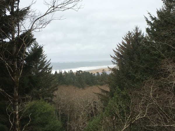
I took down some young pines and a big branch on the alder on the left to open up the view some. The beach and ocean look a bit closer in real life, as the iPhone lens is all wrong for distance shots. Since this picture was taken, I had a semi-retire tree guy come and take down these alders for $200, and he’s offered to take that spruce on the left down.
Ironically, the view to the ocean lines up perfectly with the pole barn’s far side, so that’s where the big windows and deck will go. There’s a rough trail down the gulch and into the valley. It crosses over another undeveloped parcel where those spruces are, and then hits a little road that goes right to the beach.
That’s how the beach down there looks. needless to say, Little man likes it there.
As does Stephanie, who grew up very close to the beach just a couple hours south of here, in Arcata, CA.
The pond quickly filled up this December, and a couple of frogs have started vocalizing recently.
We uncovered several other stairs and pavers and trails, all part of a system that connected this little private park with the house up a ways there that was once the owner’s house.
Stephanie uncovered a boulder garden. These were trucked in when this place was first landscaped some 25-30 years ago.
In my previous trip, I built the first third of the floor, which is one step up from the rest of it, as the existing gravel floor was sloped. The metal mesh is to keep an possible critters out.
I’m building this floor structure on top of the gravel, which is covered by two layers of an extremely tough plastic covering, not just the typical visqueen; this stuff is almost impossible to tear. That’s why I’m not using pressure treated lumber. My options were limited, as this is different than building a house, as this floor is only supporting itself and the occupants and such, as the external walls are of course already there.
Insulation batts go between the joists, and then it’s covered with 3/4″ T&G subfloor.
Having a floor has allowed us to really feel what it’s going to be like in there, and pin down the details of the floor plan, windows, doors, bath, cabinets, etc.
That resulted in two significant changes from the earlier plan: to keep the open cathedral ceiling, which will be insulated and paneled.
And to keep both the garage doors. I’ll insulate the panels and put some windows in them, and on those really nice days, it’ll be fun to just roll them up and bring the outdoors in.
In the afternoons, it’s time for a hike, especially the last few days when Stephanie came out. One day we hiked Humbug Mountain, which is just about a few miles south of Port Orford. It rises to about 1900 feet right out of the ocean, so the views on top are superb. As was the weather; about 60 degrees with zero wind. Junuary, as the locals call it. Last time we climbed this was during the summer, and it was fogged in with no visibility and there was a cold breeze to boot. This is looking south.
So many tourists don’t realize that it’s almost invariably foggy, cool and breezy in summer, and it’s often so mild and still in winter.
This is the view north, to Port orford. The town sits in that low spot between the heads and the gentle hills inland. Our place is exactly where that top of that tree is covering a part of the heads, to the left of town.
One of our favorite spots is at Cape Blanco, where the Sixes River runs into the ocean.
The trail out follows the bank of the river. We kayaked this last summer.
There’s some fine rocks just offshore.
And lots of driftwood, of course.
On this night there was a great sunset just past the tip of Cape Blanco. The lighthouse is visible a bit in from the end.
The trail then heads up towards the highlands of Cape Blanco. This viewpoint along the way is one of our favorites.
Looking back up the Sixes River valley, to the mountains from where it comes.
One afternoon I was walking through that field of tufted beach grass down there, and suddenly one tuft moved! It was a porcupine, my first sighting of one in the wild.
On the other side of the cape is a little road that drops down to a beach, that might well be hikeable al the way back to Port Orford when the tide is low. Unfortunately, all these beaches are so overrun and crowded…
The next outcropping north of Cape Blanco is Blacklock Point, a three mile hike through the forest until it breaks out on the open headland.
That’s Cape Blanco in the distance looking south, and half way there are those rocks just offshore from where the Sixes River runs into the ocean.
To the north past the bluffs is Floras Lake, just inland from that stretch of low beach up there. That’s where we used to camp before we bought our place.
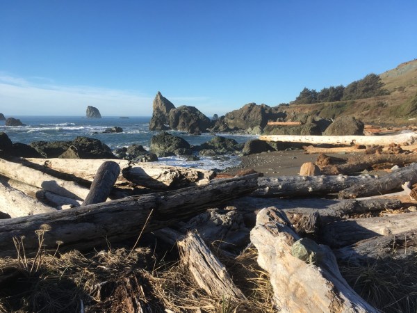
I took the steep trail that goes down to the beach, which has another prodigious collection of driftwood.
That big log in the distance tells how high the water gets here in a big storm.
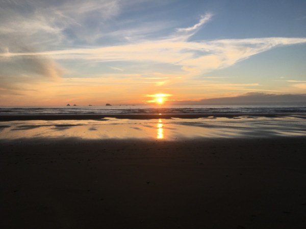
Every clear day at sunset time it’s obligatory to stop work or whatever and head out to savor it. You can see why we call it “Hawaii Northwest”. An IPA sunset.
I could go on, but I’ve probably outstayed my welcome already. And I’m eager to get done what I have to here in Eugene as it’s 63 and clear in Port Orford right now and 47 and foggy in Eugene.










“So many tourists don’t realize that it’s almost invariably foggy, cool and breezy in summer”
I found that out during a two week business trip back around 2005. It was a lovely June day when we took a Saturday drive from Portland to Astoria. In contrast, the coast was very gloomy, and the area reminded me of late winter in the Great Lakes region.
Glad to hear your new homesite is pleasant this time of year.
It happens in Maine, too, especially on the peninsulas and islands.
When I worked at Redwood NP I found the weather to be a version of the San Francisco weather I was used to. Crescent City could be cold and foggy and a few miles inland I could go swimming in a river in the warm sun. Port Orford is a notch farther north – too far north for coast redwoods which range from Santa Cruz (enough rain) to the California/Oregon border (too cold).
SF residents enjoy smirking at tourists going out in shorts and a tank top at 10 am – and then buying Fisherman’s Wharf fleece jackets later. I particularly remember working at SF Maritime for July 4th fireworks and freezing my azz. As Mark Twain never actually said, “the coldest winter I ever spent was summer in San Francisco”.
So, what exactly is a pole barn?
http://www.diypolebarns.com/learn/what-is-a-pole-barn/
It looks like you answered your question. The most cost effective way to enclose a space with a roof and walls, hence their ubiquity in an ever wider range of applications.
Have you met Ron and Anna yet, they live on the back side of Humbug off the highway ?
.
I’m kind of wondering how a person who hangs out at a car site doesn’t know what a pole barn is. Of course, I live in rural Michigan where ( almost) every home has a pole barn. Sometimes two.
“Telephone” pole barn! That’s an interesting twist. We often call them “Morton buildings” after the primary (or at least most known) brand here.
I know about pole barns. I know about barn cats. Are barn cats in pole barns called polecats? 🙂
Just stunningly beautiful! Thanks for the update and pics!! 🙂
I visited a friend out in Portland in 2015. This was one of the views I took the day we rode motorcycles out to the Pacific. DFO
You certainly live in a beautiful neighborhood! Thanks for sharing, most of us have some kind of dream of “country living” and you have found yours. Good to see you enjoying it!
In case you were wondering it was -19F (-28C) in Orford New Hampshire this morning.
Thanks for the update Paul and Stephanie. I appreciate the diversion from our standard CC fare. We had both -20C and 40cm of snow this week, so a glimpse of moderate climate is doubly welcome.
Great idea to make the pole barn into a cabin too. Enjoy!!
Good update, what an awesome place I can see why you bought it
It looks like your well on your way to making that a great vacation spot. I’m quite envious of the weather you guys get this time of year compared to the cold and cloudy days here in the midwest. Your pictures take me back to a short trip I was on to northern California a few years ago, and I loved every minute of it. The pacific northwest is truly a unique and beautiful place.
Very nice. Reminds me of Northern Michigan.
Just beautiful Paul .
‘Pole Barns’ have changed a lot since i remember them in the early 1960’s .
This looks like a very nice retirement spot, not just a vacation house .
-Nate
I’ve been on Cape Blanco
A great new adventure – congratulations!
I enjoyed this a lot. I loved reading the history of the old rescue station and those sturdy old boats that served for so many years. That would have taken a special breed of guy to brave the kind of weather that made those jobs necessary.
I also enjoyed seeing your solutions for water and power. This looks like it is a fantastic place!
Welcome to Port Orford. We live on the lake, with a view of the ocean. You couldn’t have found a more welcoming town!
Great story and great pictures, thanks for those!
I visited there while staying with family in Reedsport back in 1984, and never again after that. Time to get back I guess, I still love the coastline there.
Wife and I like taking a drive down the coast in spring starting from Westport, WA on down to Crescent City, CA and then I5 back to Tacoma. We seem to always end up stopping in Port Orford for lunch, usually up on the bluff overlooking the boats on the pier down below.
Btw! Have you been to Pig and Pancake!? If not do so when you get a chance.
Almost bought a place down in Brookings, but the wife just wasn’t quite ready to leave kids and grandkids behind yet.
Stay warm down there and enjoy 🙂
…because most reversing lamps, including the ones on your van, are more or less adequate for advertising your rearward motion to a nearby observer, but useless for lighting your way. Yours are way up high, too, which aggravates the matter. To address this, get a pair of these lamps (specifically).
You can surface-mount them with these black brackets or these chrome ones. Or, you can mount them under the bumper and/or under the rear rail of your trailer with these grommets and these brackets.
Mount them as widely spaced as possible, and you might want to walleye them slightly. They’ll provide a great deal of well-spread light on the ground, and they draw very low current so there’s no need for relay. No bulb burnouts, totally waterproof, etc. Tap into the existing reverse lamp feed wires. It’s best not to use the fold-over-and-crunch “Scotchlok” type taps. Much better, more durably trouble-free result if you use Posi-Taps; if you get an assortment like this, you’ll surely find uses for them (they’re one of those products that you buy for a particular project, but then other uses for them keep popping up in front of you once you have them).
Those lights do help alot. A buddy of mines uncle owned a body shop, one of the services he offered was cutting bumpers on plow trucks (pickups) and fitting a pair of these in the bumper (the incandescent version back then). I mounted a set under the bumper of my ram charger with brackets I used a relay to be able to switch manually or with a trigger from the existing backup lamps. They were great but frequent offroading meant I ripped them off several times.
Those Coast Guard Surfmen are an entirely different breed from most of us. They used more courage and testosterone than any amount of diesel fuel. This early lifeboat was likely more of a bobber in sea storms and appears dwarfed in size by the next generation and especially modern lifeboats. Such a wonderful spot you found with its multiple estuaries and hiking trails. Yet it’s high enough up to be safe from storms and God forbid a tsunami.
Re Slash Piles: Would there be any advantage in renting a chipper?
Great photos. Thanks.
My summer place, self-built about 18 years ago, still has no internal plumbing. A five gallon container perched on a shelf cantilevered over the sink, with a bucket under, serves so well in kitchen and bath, there is no need for ‘modern’ elaboration. (The shower stall uses an Ivation rechargeable pump unit immersed in a bucket of hot water).
I use ten foot sections of gutter on either side of the place to feed my needs and the garden’s needs. A single intense 10 minute shower will fill the 55 gallon barrels to the top. It always amazes me how much water there is in a rainstorm.
(Not sure if I got the right photo, or not)
The photo shows an early primitive setup that has been upgraded since. But you get the idea.
I have to ask – have you sampled The Crazy Norwegian’s Fish and Chips yet ?
Oh yes; several times. Very good, but I would prefer that the ratio of fries to cole slaw was a bit less extreme.
The Red Fish is excellent, and of course a bit more expensive. But well worth it.
It’s looking good, we visited Gold Beach and Port Orford on Thanksgiving weekend. On the positive side the scenery was great as was the transition from down jacket weather in Bend to T-shirt weather on the coast. On the minus side, there was enough rain and grey skies to remind us why we moved from Beaverton to Bend,
Really beautiful property and awesome project