When I was a little kid, I was fascinated by maps. Old ones were especially interesting. I was surprised to see on some local maps that there was this prosperous-looking town about a mile from my house called “Littleton”, which even had its own post office. However, all I could see when I went to that location was two highways crossing, a gas station, and a couple of average-looking buildings that one might find at any typical intersection. It certainly didn’t look like a town to me. So I decided to investigate further . . .
Blue circle: Town of Littleton, about 3 miles north of Morristown, NJ; about 30 miles west of New York City. Green: Modern highway route numbers. Red “X”: Approximate location of the house I grew up in.
Modern map from Google. There is no town of “Littleton”, however Route 202 is still called Littleton Road.
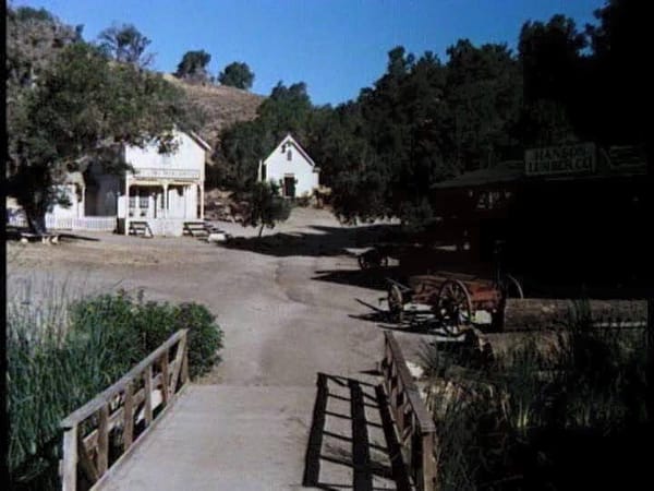
Town of Walnut Grove, from the TV series Little House on the Prairie. I suspect Littleton in its heyday looked something like this.
So one day in the 1990s (can’t remember the exact year) I drove over there, and I brought my camera with me because I heard that the area was soon going to be redeveloped. I parked on this abandoned section of roadway in the center of what was the town. I can imagine that chickens and pigs once roamed the street, the stagecoach came to town on a regular schedule, and in the distance you could hear a blacksmith hammering on horseshoes made from locally-mined iron from the nearby hills.
Last remnants of Littleton. Although there have been later alterations, these houses probably date from the late 18th to early 19th centuries. When Route 10 was laid out in the 1930s, the original main street (with its potholed pavement) was bypassed. The 1972 Mercedes 250 was my daily driver back then.
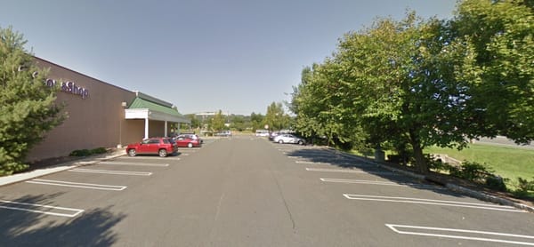
A Stop & Shop supermarket was built, its parking lot obliterating any trace of the old village.
View from Route 10. Drivers in cars whizzing by at high speed probably never noticed the small houses clustered together.
Nothing left now except that old evergreen tree at far right.
Pyramid-roofed building at the corner was the only store still in business.
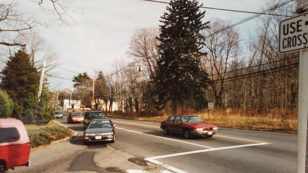
Traffic on Route 10 (which started out as the Minisink Trail, blazed by the Lenni Lenape Indian tribe) blasts through the village site. No one would ever know there was a town here.
Looking north on 202 toward Littleton.
Not much to see now. The road was made even wider.
A little farther down 202, still looking north. The large pine tree was planted in the front yard of a house that had long since vanished. On the far left there was another abandoned “haunted house”. I had previously explored the inside, which was full of old furniture and junk. It had already been demolished by the time these photos were taken.
Same view today.
Last surviving building of old Littleton. The one-room schoolhouse (also used as a chapel) was built in 1796. Located just north of Route 10 on Route 202, it is surrounded by roads, parking lots, and modern buildings. It has been preserved as an historic landmark.
A little ways up on 202 is this house, which was constructed in the early 20th century using bits and pieces of other demolished houses. So maybe parts of lost Littleton made their way here. However, this house was itself demolished last year.
At the northwest corner of Route 10 & 202 was the Alderney Milk Barn.
Mildred Cicala Abbate standing in front of the Alderney Milk Barn.
The barn was later remodeled into the SIP & SUP restaurant. Today Wendy’s occupies the site.
Stone dam over the Malapardis Brook near Littleton, forming “the ole swimmin’ hole.” This too may not remain much longer as a new development plan is scheduled to begin soon.
Forgotten Littleton has nonetheless achieved a claim to fame in modern times. Although it is one that the “salt of the earth” Colonial and Victorian folks who once lived here would never have imagined . . .
This Raceway gas station on the southwest corner of Routes 10 & 202 . . .
. . . is where Tony Soprano* (of the TV show The Sopranos) got “whacked”!
*According to a commenter, it was Phil Leotardo who got whacked.
Yes, what would the folks who built, settled, and lived their lives in this small village think of what has become of it? Butchers, bakers, candlestick makers . . . farmers, stage coach drivers, miners–real people. If they were teleported ahead in time–and saw wheeled vehicles moving faster than anything they had ever seen; all their houses gone, with only the schoolhouse as a point of reference. They would be dumbfounded beyond words.
Actually, there are lots of lost towns throughout New Jersey, and some of them have interesting names: Ong’s Hat [There was this man named Ong, and he had a hat, and he threw it in a tree . . .]
Also Quibbletown, Chairville, Double Trouble, Seven Stars, Martha Furnace, Buttzville . . . There’s even a Shades of Death Road in Sussex County.
Which leads me to this: Will your house (and the street it’s on) still be around in 100-200 years? If so, what will it look like? Who will be living there? Buildings rise and fall, but we usually think of a town as permanent–but, like Littleton, quite a few of them “are no longer on the map.”
There are many forgotten towns of New Jersey. There is a book by that name, Forgotten Towns of New Jersey. I grew up in the colonial capital of West Jersey, Burlington. My grand parents on my mother’s side grew up on the Indian reservation in Shamong Township. My fathers side of the family came to Burlington in 1645 and our plantation, Peach Field is still standing. Much has changed in NJ and much has been forgotten.
I’m loving these little diversions back to my home state. On my last visit to Sussex County over Christmas week I was disheartened to see even more buildings and homes that I’d been familiar with since the early 70’s now gone in favor of development. There’s a fairly strong contingent of historic-minded folks who work hard to keep the “flavor” of the area intact, but of course time marches on and they can’t all be saved. I had a good friend years ago who lived in Mt Tabor and was very interested in the history and vibe of her little hamlet. We lost touch, but I always admired her enthusiasm for the place, another interesting NJ settlement.
Dear MTN-
I am related to the Littles of Littleton, and I live in Mt. Tabor, and was one of the founders of the Historical Society here. I’m sure I know of your friend you mention who lived in Mt. Tabor, who “was very interested in the history and vibe of her little hamlet”, as you wrote there. What is her name? -JOH
Hello JOH, when I was 10 years old (65 years ago) my grandmother from east orange would drive us to “Littleton” as she called it for a day of swimming. It was a spring fed pond, good size, a challenge to swim out to the floating pontoon for me and my brothers!
There was an abandoned old concrete block structure there that we used as a place to change our clothes. A bit spooky for us boys! Wondering what ever became of our beautiful pond!
In the Buster Keaton movie, “Our Hospitality”, his character’s aunt warns him as he boards the primitive train to ride off to Appalachia, to be “careful” of the wild Indians in New Jersey.
Growing up in Cook county Illinois, the City swallowed up small towns. Larger ones that were swallowed up became suburbs and more than a few disappeared altogether. There are over 130 still left, the rest becoming aldermanic wards in Chicago.
I don’t know about Littleton, but I used to visit Morristown frequently for work. A beautiful town, the old downtown area was nice to visit in the evenings.
There’s still quite a few places like this in the remote parts of the West, because development never happened.
What would the folks of Littletown think? They probably would think all the development was awesome. That’s what America has been all about, right? Build quick, cheap and expedient wooden houses and hope the railroad comes through and make some money and sell out and move on the the next opportunity. There’s always gold in them thar hills…
“Will your house (and the street it’s on) still be around in 100-200 years?”
I’d expect my current home will continue on, as it’s deep in an established subdivision with no real threats of redevelopment.
However, but my Grandfather’s farm house survived a similar neighborhood upheaval. It’s located in Minnesota, and back in the seventies mechanization led to the consolidation of many family farms, and the removal of many family homes.
As a kid I remember passing four or five other farmhouses on the way to my Grandfathers house. Today, those other homes, barns and groves are all cornfields, but Grandpa’s house remains standing. The house is no longer owned by my family, but when I visit the area, I-90 takes me right past the property (a little west of the Wells/Kiester exit). The house and still occupied and well maintained, unlike many farmhouses in the area.
I’m not sure the exact build date, but at this point the house is around 130 years old.
My home town of Bridgeton Mo. was originally given the Name of “Marais de Liards” by French explorers travelling on a well known native trail. It then became known av Village a Robert, then Robertsville, then Bridgeton, all in short order after the area around St. Louis was ceded to the U.S in the Louisiana purchase. A lot of history remains but the old town center is now under a taxiway of the St.Louis Lambert international airport. In fact my old child hood and adolescent neighborhood, a planned 1950s and 60s Mid Century Modern community, was razed as well due to its proximity to the Airport expansion and is now all wildland. Not parkland, Wild land. Much as it was in the beginning.. only a few crumbling roads remain, chained off from traffic. The other end of my neighborhood area survives as Creve Coeur park and a suburb of the same name. the natural lake in the park given that name by French cartogtaphers in the early 1700s. To everything, there is a season.
On that early map, what, or would the settlement have been labeled had there not been a post office there to serve the surrounding area? That’s what “Littleton P.O.” designated.
I love to examine seemingly random of often-forgotten-about buildings, towns, etc., so I appreciate this article and especially your old pictures. Since hardly anyone takes pictures of everyday places (well, at least in the pre Google StreetView era), these are likely the only photos in existence of these Littleton buildings in the late 20th century.
From an automotive perspective, it’s great to see the cars on the road. I can just picture that reddish/orangish Nova heading home from the local high school, for instance.
And the buildings, etc. — while unremarkable from a historical or uniqueness context — are wonderful because the most easily forgotten memories are those that seemed commonplace. For instance, the tenant of the pyramid-roofed building was “Abra Cadabra Color Copy Center.” When was the last time you saw a “color copy center” that wasn’t a FedEx? But back 30 years ago, they were everywhere, and often in repurposed old buildings with cheap rent like this one.
I’ll just leave you with a picture from my own collection (I didn’t take this picture… just happen to have it) — this was the parking lot of our local library in 1983. This building was demolished about 15 years ago to make way for townhouses.
I live in what is touted to be the youngest major city (pop. 500k+) in the US. The only city in the US of its size to be founded in the 20th century. Incorporated in 1911, but the real growth didn’t begin until after WWII (the invention of air conditioning was truly a necessity for that to happen!)
As such, there is virtually no building left (outside of museums) from before the late 1940s and indeed very little from before the 1960s. It is a city that has no reverence for history.
I have driven along Routes 10 and 202 for more than forty years. It is a bustle of traffic on Route 10. I never realized what had been eradicated and, truthfully, LOST! Thanks for the expose. Sad to see history replaced by progress – if that is what it is.
This is fascinating stuff. We Americans are a restless people. I live several states to the west which makes things much younger, but even here we have places disappearing and being replaced by roads. Or old sections of major cities that have become decayed slums, only to be torn down and built over.
I have wondered about the long term fate of my mid-century suburban subdivision. Will it eventually have to go through a period of decay then re-development? Who knows.
Hate to be a pessimist, but my childhood neighborhood has become quite the slum, forcing my mom out, stranding old timers behind barred doors and hurricane fences with only a fraction of their home values.
My mom’s childhood neighborhood had been razed and sits empty. Working class, blue collar neighborhoods where punch-clock men and their wives raised many kids is as obsolete as a log cabin. At the university, towns like mine were referred to as “incubator towns” – where the lower working class made babies.
True – my little block has 72 school-aged kids I all knew, and the neighborhood probably had about 45 of those blocks. The town went from a population of 800 to 15,000 in a decade – now it is down to 7500 filled with abandoned lots and vacant houses. Sad.
If town is unincorporated, not much stands in way. In Chicago area burbs, there are a few ‘hamlets’ surrounded by newer suburban homes. Like Keeneyville or Medinah.
Towns that did incorporate, sometimes grew exponentially, but some did leave intact little town centers, usually by train stations. Examples are New Lenox, Orland Park or Naperville IL. Warrenville incorporated in 1967, was once ‘largest unincorporated town’ in IL. If not, may have gotten annexed by Naperville.
Unincorporated and far from trains, then usually paved over. Example is Cloverdale, was near big burb of Bloomingdale, looked like a small farm town in 1980’s, now gone.
I’ve not been back home for many years but all over New England’s towns & cities the highways grew ever wider and looked just like the picture or route 10 , cars whizzing by .
I watch in dismay as older homes get torn down and replaced by apartments, I hope my little house lasts as long as I do , it’s definitely what’s called a “teardown” now .
As controversial as it may be to mention on CC, it’s the particular demands of the car (when it becomes the sole transportation option for almost everyone) that has resulted in much of the built landscape we see around us.
I grew up in, and have returned to, Redondo Beach, California. Incorporated in 1882, it was established by the railroads as the de facto “Port of Los Angeles”. Later, it became a seacoast resort town and then a bedroom community attached to Los Angeles. It grew steadily until all the vacant land was used up in the 1970’s. Today, many early 20th Century buildings remain, but simple mid-century stucco boxes, like my 1946 example, are slowly being replaced by $3M mini-mansions. I dont see massive change in 100 years, if the last 100 are any guide.
Picture of downtown Redondo Beach, 1924. It is typical Los Angeles commercial architecture of the era.
Neat article. My (step) grandmother lived in Mahwah, NJ, which I think route 202 also snakes up through (my maternal grandmother died 19 years before I was born, my grandfather remarried, she moved to NE Pennsylvania where my grandfather lived).
I didn’t spend much time in Mahwah, but did get to stay there for a couple business trips in the 1980s; she worked at an ice-cream parlor where a restaurant was in the 80’s so of course I had to eat there during both trips (I live about 1700 miles away so don’t get to visit much).
The other odd road thing for me, my family moved around a lot in my parent’s younger years, but I got my first job out of college a block away from a road…that was a block away from the home they lived in when I was born (abeit in another town, miles distant from where I ended up).
Both grandparents immigrated from Slovakia…though my grandfather was from a different part of the country than my (step) grandmother…even the town he was from had 2 different names…he was actually born in Kerestur (in the Austro-Hungarian empire) which was later renamed Zeplinska Teplica which describes the area of the country and the fact they had a warm spring there. My grandfather (nor either grandmother) were ever able to go back to visit; partly because of the communist occupation (my grandfather died in 1966) though my (step) grandmother could have visited by the 90’s when things opened up she was in her 80s…we did get to visit the areas where both my grandfather and step grandmother lived, and likewise have had relatives visit us here.
There’s often a reason for the name change that has something to do with the history of the area. Slovakia is in the crossroads of Europe, and has been occupied much of its history by factions from other areas such that the amount of time they actually ruled their own country was actually pretty brief….they were combined with Czech republic after WWI and weren’t independent until 1993…before WWI they were part of Austro-Hungary, which lasted quite a while before that.
Thank you for giving me a glimps of where my 4th Great Grandfather & Mother lived. Yes Littleton. I wish I knew more about them. It appears their information as disappeard with them as Littleton disappeared. I live in Indiana so this is great to find on line !! Thanks














There are many forgotten towns of New Jersey. There is a book by that name, Forgotten Towns of New Jersey. I grew up in the colonial capital of West Jersey, Burlington. My grand parents on my mother’s side grew up on the Indian reservation in Shamong Township. My fathers side of the family came to Burlington in 1645 and our plantation, Peach Field is still standing. Much has changed in NJ and much has been forgotten.
I’m loving these little diversions back to my home state. On my last visit to Sussex County over Christmas week I was disheartened to see even more buildings and homes that I’d been familiar with since the early 70’s now gone in favor of development. There’s a fairly strong contingent of historic-minded folks who work hard to keep the “flavor” of the area intact, but of course time marches on and they can’t all be saved. I had a good friend years ago who lived in Mt Tabor and was very interested in the history and vibe of her little hamlet. We lost touch, but I always admired her enthusiasm for the place, another interesting NJ settlement.
https://en.wikipedia.org/wiki/Mount_Tabor,_New_Jersey
Dear MTN-
I am related to the Littles of Littleton, and I live in Mt. Tabor, and was one of the founders of the Historical Society here. I’m sure I know of your friend you mention who lived in Mt. Tabor, who “was very interested in the history and vibe of her little hamlet”, as you wrote there. What is her name? -JOH
Hello JOH, when I was 10 years old (65 years ago) my grandmother from east orange would drive us to “Littleton” as she called it for a day of swimming. It was a spring fed pond, good size, a challenge to swim out to the floating pontoon for me and my brothers!
There was an abandoned old concrete block structure there that we used as a place to change our clothes. A bit spooky for us boys! Wondering what ever became of our beautiful pond!
Tony didn’t get whacked, but I believe that one is where Phil Leotardo was whacked.
Yup. It’s on Youtube. Before you click the link I need to warn you that it’s pretty gruesome.
Oh gese! Now you tell me 🤯
You mean hilarious!
In the Buster Keaton movie, “Our Hospitality”, his character’s aunt warns him as he boards the primitive train to ride off to Appalachia, to be “careful” of the wild Indians in New Jersey.
There are few finer things than an Arbuckle, Keaton, and St. John comedy,
particularly if Luke the dog is involved.
Growing up in Cook county Illinois, the City swallowed up small towns. Larger ones that were swallowed up became suburbs and more than a few disappeared altogether. There are over 130 still left, the rest becoming aldermanic wards in Chicago.
I don’t know about Littleton, but I used to visit Morristown frequently for work. A beautiful town, the old downtown area was nice to visit in the evenings.
The neighborhood I live in dates back to circa 1850 and many of the homes, including
ours, look much as they did in images from the 19th century. There is a warmth
(psychological only!) to old buildings that is nearly entirely absent from more modern
structures.
There’s still quite a few places like this in the remote parts of the West, because development never happened.
What would the folks of Littletown think? They probably would think all the development was awesome. That’s what America has been all about, right? Build quick, cheap and expedient wooden houses and hope the railroad comes through and make some money and sell out and move on the the next opportunity. There’s always gold in them thar hills…
“Will your house (and the street it’s on) still be around in 100-200 years?”
I’d expect my current home will continue on, as it’s deep in an established subdivision with no real threats of redevelopment.
However, but my Grandfather’s farm house survived a similar neighborhood upheaval. It’s located in Minnesota, and back in the seventies mechanization led to the consolidation of many family farms, and the removal of many family homes.
As a kid I remember passing four or five other farmhouses on the way to my Grandfathers house. Today, those other homes, barns and groves are all cornfields, but Grandpa’s house remains standing. The house is no longer owned by my family, but when I visit the area, I-90 takes me right past the property (a little west of the Wells/Kiester exit). The house and still occupied and well maintained, unlike many farmhouses in the area.
I’m not sure the exact build date, but at this point the house is around 130 years old.
My home town of Bridgeton Mo. was originally given the Name of “Marais de Liards” by French explorers travelling on a well known native trail. It then became known av Village a Robert, then Robertsville, then Bridgeton, all in short order after the area around St. Louis was ceded to the U.S in the Louisiana purchase. A lot of history remains but the old town center is now under a taxiway of the St.Louis Lambert international airport. In fact my old child hood and adolescent neighborhood, a planned 1950s and 60s Mid Century Modern community, was razed as well due to its proximity to the Airport expansion and is now all wildland. Not parkland, Wild land. Much as it was in the beginning.. only a few crumbling roads remain, chained off from traffic. The other end of my neighborhood area survives as Creve Coeur park and a suburb of the same name. the natural lake in the park given that name by French cartogtaphers in the early 1700s. To everything, there is a season.
On that early map, what, or would the settlement have been labeled had there not been a post office there to serve the surrounding area? That’s what “Littleton P.O.” designated.
I love to examine seemingly random of often-forgotten-about buildings, towns, etc., so I appreciate this article and especially your old pictures. Since hardly anyone takes pictures of everyday places (well, at least in the pre Google StreetView era), these are likely the only photos in existence of these Littleton buildings in the late 20th century.
From an automotive perspective, it’s great to see the cars on the road. I can just picture that reddish/orangish Nova heading home from the local high school, for instance.
And the buildings, etc. — while unremarkable from a historical or uniqueness context — are wonderful because the most easily forgotten memories are those that seemed commonplace. For instance, the tenant of the pyramid-roofed building was “Abra Cadabra Color Copy Center.” When was the last time you saw a “color copy center” that wasn’t a FedEx? But back 30 years ago, they were everywhere, and often in repurposed old buildings with cheap rent like this one.
I’ll just leave you with a picture from my own collection (I didn’t take this picture… just happen to have it) — this was the parking lot of our local library in 1983. This building was demolished about 15 years ago to make way for townhouses.
That photo would make a great car-spotting exercise. So much “everyday iron” for the time represented there.
I live in what is touted to be the youngest major city (pop. 500k+) in the US. The only city in the US of its size to be founded in the 20th century. Incorporated in 1911, but the real growth didn’t begin until after WWII (the invention of air conditioning was truly a necessity for that to happen!)
As such, there is virtually no building left (outside of museums) from before the late 1940s and indeed very little from before the 1960s. It is a city that has no reverence for history.
“It is a city that has no reverence for history.”
…only for money. Mostly money that nonresidents flock there and bring, only to leave behind.
I have driven along Routes 10 and 202 for more than forty years. It is a bustle of traffic on Route 10. I never realized what had been eradicated and, truthfully, LOST! Thanks for the expose. Sad to see history replaced by progress – if that is what it is.
This is fascinating stuff. We Americans are a restless people. I live several states to the west which makes things much younger, but even here we have places disappearing and being replaced by roads. Or old sections of major cities that have become decayed slums, only to be torn down and built over.
I have wondered about the long term fate of my mid-century suburban subdivision. Will it eventually have to go through a period of decay then re-development? Who knows.
This is Detroit:
Hate to be a pessimist, but my childhood neighborhood has become quite the slum, forcing my mom out, stranding old timers behind barred doors and hurricane fences with only a fraction of their home values.
My mom’s childhood neighborhood had been razed and sits empty. Working class, blue collar neighborhoods where punch-clock men and their wives raised many kids is as obsolete as a log cabin. At the university, towns like mine were referred to as “incubator towns” – where the lower working class made babies.
True – my little block has 72 school-aged kids I all knew, and the neighborhood probably had about 45 of those blocks. The town went from a population of 800 to 15,000 in a decade – now it is down to 7500 filled with abandoned lots and vacant houses. Sad.
And it’s not only in America, it happens also in Canada.
Laurier Blvd/QC-175, Québec City 2021 https://goo.gl/maps/F6fADCo89FEB1Mug8
Same place back in 2009 https://goo.gl/maps/UWS3cRamqXQCrpYn7
Btw, that reminds me of a thread on Skyscraperpage forums about big landscape and cityscape changes on StreetView.
https://skyscraperpage.com/forum/showthread.php?t=249429
If town is unincorporated, not much stands in way. In Chicago area burbs, there are a few ‘hamlets’ surrounded by newer suburban homes. Like Keeneyville or Medinah.
Towns that did incorporate, sometimes grew exponentially, but some did leave intact little town centers, usually by train stations. Examples are New Lenox, Orland Park or Naperville IL. Warrenville incorporated in 1967, was once ‘largest unincorporated town’ in IL. If not, may have gotten annexed by Naperville.
Unincorporated and far from trains, then usually paved over. Example is Cloverdale, was near big burb of Bloomingdale, looked like a small farm town in 1980’s, now gone.
Tangent: Anyone else remember looking at Algoe, NY, on maps?
Thank you for another great article ! .
I’ve not been back home for many years but all over New England’s towns & cities the highways grew ever wider and looked just like the picture or route 10 , cars whizzing by .
I watch in dismay as older homes get torn down and replaced by apartments, I hope my little house lasts as long as I do , it’s definitely what’s called a “teardown” now .
-Nate
Nice piece!
R. Crumb did a famous cartoon sequence documenting this kind of change.
https://klaustoon.wordpress.com/2020/06/19/an-analysis-of-a-short-history-of-america-by-robert-crumb/
As controversial as it may be to mention on CC, it’s the particular demands of the car (when it becomes the sole transportation option for almost everyone) that has resulted in much of the built landscape we see around us.
I grew up in, and have returned to, Redondo Beach, California. Incorporated in 1882, it was established by the railroads as the de facto “Port of Los Angeles”. Later, it became a seacoast resort town and then a bedroom community attached to Los Angeles. It grew steadily until all the vacant land was used up in the 1970’s. Today, many early 20th Century buildings remain, but simple mid-century stucco boxes, like my 1946 example, are slowly being replaced by $3M mini-mansions. I dont see massive change in 100 years, if the last 100 are any guide.
Picture of downtown Redondo Beach, 1924. It is typical Los Angeles commercial architecture of the era.
Neat article. My (step) grandmother lived in Mahwah, NJ, which I think route 202 also snakes up through (my maternal grandmother died 19 years before I was born, my grandfather remarried, she moved to NE Pennsylvania where my grandfather lived).
I didn’t spend much time in Mahwah, but did get to stay there for a couple business trips in the 1980s; she worked at an ice-cream parlor where a restaurant was in the 80’s so of course I had to eat there during both trips (I live about 1700 miles away so don’t get to visit much).
The other odd road thing for me, my family moved around a lot in my parent’s younger years, but I got my first job out of college a block away from a road…that was a block away from the home they lived in when I was born (abeit in another town, miles distant from where I ended up).
Both grandparents immigrated from Slovakia…though my grandfather was from a different part of the country than my (step) grandmother…even the town he was from had 2 different names…he was actually born in Kerestur (in the Austro-Hungarian empire) which was later renamed Zeplinska Teplica which describes the area of the country and the fact they had a warm spring there. My grandfather (nor either grandmother) were ever able to go back to visit; partly because of the communist occupation (my grandfather died in 1966) though my (step) grandmother could have visited by the 90’s when things opened up she was in her 80s…we did get to visit the areas where both my grandfather and step grandmother lived, and likewise have had relatives visit us here.
There’s often a reason for the name change that has something to do with the history of the area. Slovakia is in the crossroads of Europe, and has been occupied much of its history by factions from other areas such that the amount of time they actually ruled their own country was actually pretty brief….they were combined with Czech republic after WWI and weren’t independent until 1993…before WWI they were part of Austro-Hungary, which lasted quite a while before that.
Thank you for giving me a glimps of where my 4th Great Grandfather & Mother lived. Yes Littleton. I wish I knew more about them. It appears their information as disappeard with them as Littleton disappeared. I live in Indiana so this is great to find on line !! Thanks